Pendle Hill Walks

If you drive along the eastern end of the M65 Pendle hill is impossible to miss. At 1827 feet it is easily the highest point in the area. Perhaps you’ve gone passed many times and never got around to walking up it, perhaps you’ve got a familiar route up Pendle and feel you know it well or maybe you are a visitor to Lancashire, have heard tales of the ‘Pendle Witches’ and are keen to make the acquaintance of this well-known landmark. Either way, I hope this will encourage you to take another walk up Pendle and to see it afresh from a different angle.
I am fortunate to be able to see Pendle from my bedroom window and often take the dogs for a walk up there. It served as an ideal place to practise for my Yorkshire Three Peaks walk too. The view of Pendle from the motorway makes it appear a simple, solid elongated lozenge shape, but there are several ‘fingers’ to it forming steep valleys which, depending on your approach, you may go down and up before reaching the summit.


Walking Pendle with Dogs
Pendle is sheep farming country and home to a lot of ground nesting birds so it is important to keep your dog under close control and not allow it disturb these animals. Some routes avoid stiles altogether so are walkable with most breeds of dog, some routes have quite difficult six foot high wooden stiles which agile dogs can manage unassisted, but others need a lot of help. It would not be sensible to attempt to get a giant breed of dog over the biggest stiles! You will need to judge for yourself whether you could manage to lift your dog over these safely if necessary.
Where to Start a Walk up Pendle

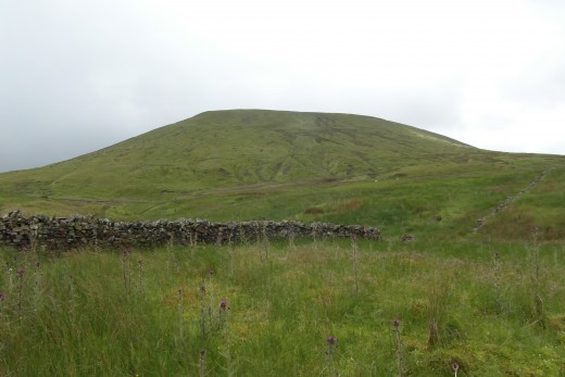
Starting option for 'Under discovered Pendle' walk.
alternative start for Underderdiscovered Pendle Walk
Pendle Walk from Barley
Best for: A cardiovascular workout or an evening walk when you might see the sunset as it goes behind the hill. This route avoids stiles if (you or) your dog struggle to get over them.
Mileage: Just over four miles.
Barley is an attractive village to the East of Pendle. This route is known locally as ‘The Big End’ because it is the steepest way up and the direction from which Pendle seems biggest. It is by far the most popular route up Pendle and on a sunny day can be very busy. There are buses to Barley from Burnley, Nelson and Clitheroe or you can drive there and park in the village car park which has an honesty box for your £1.00 parking charge.
")
")


The Route
- Take the path out of the car park across the stream and into the village. Walk past the ‘Barley Mow’ pub and the tea room on your right. Before the Methodist chapel, take the footpath on your left beside the stream.
- This path is quite well sign posted either Pendle or Pendle circular walk. Cross fields and two bridges. After the second bridge (P1) go left for a short road section.
- Then a right turn which takes you up someone’s driveway – don’t worry, this is an official footpath. Fork left past the house, then turn right through a metal kissing gate.
- After this the path is well marked and easy to follow and you can see Pendle ahead which is a handy clue to the direction!
- Once you get to Pendle you are heading literally straight up, hence the reason this walk is called going up the ‘big end’! Stone steps have been laid into the hill, to help prevent erosion because this is the most frequently used route up and down Pendle.
- Keep on going up, but do stop frequently to look back at the view (and take a breather). When it levels out you will see a wall and stile ahead. Turn left before the wall and you will see the Beacon (triangulation point) marking the top of Pendle. Go to it.
- At the Beacon take the path on the left which follows the edge of the hill. Ignore the first path down, continue along the moor to the second path down which leads to two gates with footpath signs. Go through the gate on your right.
- Head down and slightly right across the field to the farm track. Turn right and walk along the track until in comes out at Upper Ogden reservoir. You then follow the track left, passing Lower Ogden reservoir on your right, until you come back out in Barley opposite the car park.
At this point you may fancy some refreshments! Barley is well supplied by ‘The Cabin’ in the car park, the Tearooms and the pubs. Take your pick. On a Sunday, many locals prefer to go on to the Clarion Tea House a couple of miles away between Roughlee and Newtown in Pendle.
Pendle Walk from Downham
Best for: Avoiding the crowds
Mileage: A four mile circuit from the layby. 6 miles if you start from Downham
Downham is an exceptionally picturesque village to the North of Pendle. There is a car park in the village and a footpath to the layby where the walk starts, or you can park in the small layby at the start of the walk.
I call this route ‘Under discovered Pendle’. The land to south of Pendle is much more densely populated than to the north, so this route is undeservedly much less popular with walkers.

")
")
The Route
- Join the concessionary footpath which starts in the layby on the Pendle road opposite the footpath to Downham sign. The path follows the fence which is on your right hand side heading up towards Pendle.
- Cross the stile into the next field. Follow the path straight up across several small drainage rills to the gate.
- The path after this gate takes you a few degrees to the right, but heading upwards. Just before you get to the steep bit of Pendle a stone marker indicates that the goes to the left. The path zigzags but is quite well marked. Please avoid the temptation to ignore the path and head straight up. The hillside is vulnerable to erosion and the path helps reduce damage. Do look back to enjoy the view, which is especially attractive from this side of Pendle.
- When you near the top you will see a wall with a stile over it ahead. This can be quite difficult to negotiate with dogs. There is a gate but this is usually chained shut. (P3)
- Once over the stile in good visibility you will see the Pendle triangulation point (known as the Beacon) about 45 degrees to the stile. Head to it.
- At the Beacon you are taking the path which leads roughly parallel to the edge of the hill to your left. You will soon come to a path on your left which leads down the side of the hill. Follow this to the gate out on to the farm track.
- Take the track which goes left, past some fir trees, through a couple of gates and then left onto the road.
- 200 Yards along the road to your left is a footpath. Follow this path keeping the wall to your left. Go through the gate into a large, undulating, marshy and mossy field. The path sets off straight ahead. The path is quite well served by marker posts. (P4) Most of the time you will see the next marker ahead. Overall you will be gently curving leftwards until you come to the end of the field with a stile at the corner to your right.
- Cross the stile, walk through the spinney and cross the next stile onto the road. Turn left on the road and walk past the first layby and on to the second one or to Downham depending where you parked.
")
")
")
")
")
")
")
Pendle Walk from the ‘Nick of Pendle’
Best for: Early morning to watch the sunrise or if you want to avoid the steepest routes.
Mileage: Six miles
I call this route ‘The Westhead Walk’ in tribute to the man who introduced my family to Pendle when I was about 10 years old. Stanley Westhead was a Scout master with Clitheroe scouts. This route passes a cairn erected to celebrate scouting which includes a plaque commemorating him.
There is a small layby which you can park up in just past Pendle dry ski slope ( on the right if coming from Sabden).
The Route
- The footpath starts on the left of the layby setting off roughly 90 degrees to the road heading slightly uphill then down towards the stream (P5).Cross the stream with care – there is no bridge and the stones can be slippery.
- Head on uphill away from the stream. After a while you will see a dry stone wall with a small cairn at the corner. Aim for the cairn (P6).
- At the cairn you need to follow the path which runs parallel to the wall. The wall will be on your left hand side. When the wall ends the path keeps to the same line. You will see what appears to be a boulder ahead. This is deceptive – it is actually a 10ft high cairn and further away than it looks. Head to the cairn (P7).
- This beautifully made dry stone cairn was built to commemorate various scouting dates and also has a plaque to commemorate Stanley Westhead. The path from the cairn runs at a 45 degree angle to the path you were on. You are heading towards what looks like a rear tractor tire laid on its side. This is actually a small shelter. Go to it.
- No, you haven’t discovered evidence of a lost tribe on Pendle. This is a roofless walkers’ shelter (P8) and a jolly handy spot for having a sandwich on a windy day.
- From the shelter head on roughly the same line to the stile (P9), over this and make a 45 degree turn to head to the next stile. This is the same difficult stile for dogs as in the 'Under Discovered Pendle' walk.
- Over the stile in good visibility you will see the Pendle triangulation point (known as the Beacon) about 45 degrees to the right. Head to it.
- At the beacon take the path which leads North West. Ignore the one which leads roughly west along the edge of the hill. You soon get to a paved section across the bog. The bog is fragile habitat so do use the path.
- The paving ends at a gate which you go through and then cross the stream. Take the path left which runs parallel to the stream (P10) for a while, but the take the right hand fork. At a cairn the path goes a bit to the right again. You’ll notice you are walking down a gentle ridge or finger like section of Pendle.
- You will see Pendle dry ski slope (P11) on the road ahead (with floodlight on the slope). You are aiming to reach the road just to the right of the ski slope. Turn right on the road and a couple of hundred yards will take you to the layby where the walk started.
Pendle Views from the Top
Click thumbnail to view full-size


