31. Australia Road Trip: The Savannah Way - Destination: Gulf of Carpentaria.
The Gulf Developmental Road
The Savannah Way
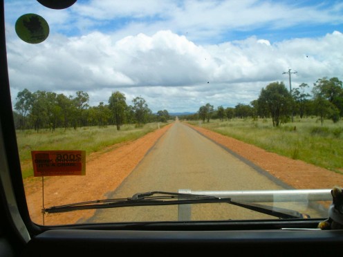
The Savannah Way crosses a vast wilderness, hot and dusty in the dry season, Hot and flooded in the wet. We travelled in the wet.
In the Wake of the Cyclone
With the road back to the coast blocked indefinitely by cyclone damage, we have no alternative other than to head west into the outback, through what is known as Gulf country. The Kennedy Highway west of Mt Garnet is also called “The Gulf Developmental Road” and that is just what it is – a road still under development. The edges of the tarmac are unfinished, ragged and crumbling, and the verges are the red dirt of Australia that becomes slippery and treacherous when wet. It is so narrow that you have to pull off the road, onto the red verge, when encountering oncoming vehicles. For the time being, this is not a problem for us as there are no oncoming vehicles in the aftermath of the cyclone. We hope the lack of eastbound traffic is not due to blockages further west, something we are going to find out soon enough. Immediately out of Mt Garnet, the road is strewn with fallen trees and debris, but the worst has been cleared overnight by the SES road crews, one of which we pass an hour out of Mt Garnet.
We can follow the path of Cyclone Larry by the shredded trees that line the roadside. After a hundred or so kilometres the damage to the bush ends, indicating the storm hadchanged direction. We later learn that Larry did indeed begin to track north after Mt Garnet and as it went further inland it decreased from a Category 5 to just a plain old tropical storm.
There is little habitation and few specific tourist attractions in the Gulf Savannah country but the Undarra Lava Tubes, located about 122kms southwest of Mt. Garnet, is one place we had originally hoped to visit. The recently discovered lava tubes are a geological phenomenon - a vast network of huge volcanic tunnels. They located at the end of a 10km diversion off the main road. The cyclone damage here is minimal, but unfortunately our sightseeing plans are scuppered as the Lava Tubes are closed to visitors until generator power can be restored much later in the day. It would mean hanging around for about three or four hours, taking a tour, then, either racing to get to the next town before dark or staying in the bushland campsite at the Tubes. We debate the decision for some time, but something tells me that all is not right out here in the wilderness, so we decide to keep moving.
The next stop, this time for fuel and a sandwich, is a real one-pub town - Mt. Surprise, population 65. The lady in the petrol station expresses an element of surprise as we are the first vehicle to pass through town, in either direction, since Cyclone Larry. (‘At last’, I think, ‘we are first at something’). Mt. Surprise (no mountain in sight by the way) is famous as a place to fossick for gemstones, though the ones on display in the antique petrol station are so dusty they have lost any resemblance to gems. We add to the general dust levels of the town as we head back onto the Savannah Way, leaving Mt Surprise forlornly behind us.
Georgetown
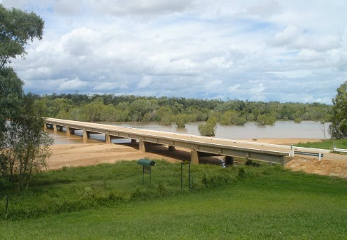
There’s not much at Georgetown either. This little town sits on the banks of the muddy Etheridge River, about halfway between Cairns and Normanton. The only pub is a rather unattractive breezeblock building. The two local drinkers sitting inside show no curiosity or interest whatsoever in the dusty stranger, me, who walks in out of the blazing sun to buy a six pack of cold Carlton Draught.
We cruise around the empty streets checking the place out. There’s a butchers, a couple of filling stations, and an Information Centre housed in a surprisingly attractive, architect designed building, which also contains an extensive Mineral & Gem exhibition, with clean, sparkling jewels on display. There are a couple of caravan parks so we pick one, the Middway, and relax for the rest of the afternoon. The pool is a welcome retreat in the stifling afternoon heat, and I discover an amusing diversion - flushing the big green frogs that live under the rims of the toilet bowls (Note: No frogs were hurt during this game, as they just swim back to the surface). There are gekko colonies in the amenities block too, and lots of bird squawking all over the place.
After a pasta supper in the shady lee of the camper, we are driven inside by relentless insect attacks. They are attracted to light, so the lamp on the outside of Winnie is a swarming mass of moths and midget flies. While mozzies buzz about our ears, beetles and moths dive bomb the citronella candle on the table until the melted wax around the flame is filled with tiny bodies. At least inside we are insect-proof, and our electric fan (nicknamed ‘Fanny’), is working overtime to create a cooling breeze. We have had a big day today and are soon asleep with an early start to look forward to.
Croyden, a one-horse town
The Dawn Chorus calls
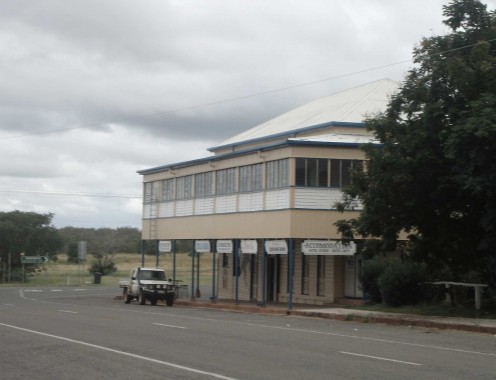
I arise just before dawn and walk down the highway to the town’s only public payphone to try to phone my daughter in England. I need to let her know that we are OK after the cyclone. In the dim, grey pre-dawn, I experience the most amazing sensation – the outback dawn chorus. The cry from a thousand curlews echoes about me. I listen hard and their haunting call seems to fill every crevasse of sound space. I can hear their plaintive wails coming from far out in the wild savannah that surrounds the town like a dark ocean. Meanwhile the silhouettes of a hundred other species dart and swoop against the lightening sky. It is a sensational thing to see and hear, spooky too.
The phone box, with it’s buzzing flourescent light, is home to every know species of Australian flying insect; luckily I Aerogarded myself before I set off. It takes a while to key in all the numbers and feed the pocketful of dollar coins into the slot but I am at last able to get Rachel on her mobile. Her response when I tell her we are OK is “Huh? What cyclone?” How news doesn’t travel. I fight my way out of the booth through clouds of beetle-like beasties and flying stick-insects and hurry back to camp to prepare for the early start.
We leave Georgetown at 8.00am and continue west to Croydon, 148 lonely kilometres away. The road is long, and in two and a half hours of driving we only meet two oncoming vehicles heading east. Nothing overtakes us going west, nothing. We reach Croydon at 10.00am. It’s another one-pub town, historic too, as it was once a large gold mining centre, a hundred years ago. We fill-up, have a bad coffee, and then it’s off again on the final 148km stretch to Normantown. These distances don’t sound great but you must consider that there is absolutely nothing along the route other than the road itself. Occasionally we pass a sign pointing to a cattle station or two, perhaps 80 or 90kms down a flooded dirt road, but there is really nothing other than that. And our old van drives at 80kmh flat out, so any distance is a long way at that speed; it adds to the adventure I suppose, though I do at times wonder if we haven’t made a huge mistake with the vehicle, that being said, old Winnie is running like a dream (touch wood!).
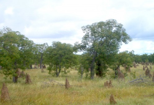
Some 30kms out of Croydon and we are in true Gulf Savannah country. Dead flat with flooded grassy plans and a thin forest of trees that stretches to infinity. Termite mounds, or anthills as I incorrectly refer to them, are everywhere. They are about a metre high on average and some are naturally ornate and decorated, like fairy tale castle spires. The overall effect however, is of a forest of stumps, or a vast graveyard of red, pointed tombstones.
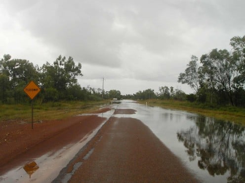
Signs along the road warn of Foodways, where stretches of road can be covered with water. We hit our first big puddle and cruise through it. A few kilometres later and we sail through a hundred metre long lake on the road. Winnie sputters a bit but we keep on rolling.
Floodway
At Creen Creek
The Creen Creek Crew
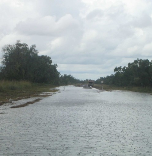
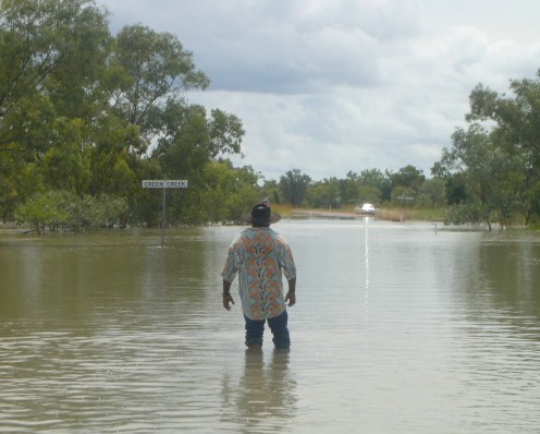
It was sunny and dry when we left Georgetown this morning, but now random rain squalls are pelting down, making the road steam. 38kms out of Croyden we come to Creen Creek and it’s truly flooded. A skin of water covers the road for about 500 metres. It is about half a metre deep but in the middle it flows across the road with a swift and daunting current where the creek itself has breached its banks. I put on my new Crocs (the footwear not the reptile!) and walk out into the flood a short way, just over ankle deep, but I soon retreat as the heavens open and the monsoon chucks it down.
We sit in the van contemplating our options, none of which are appealing. Half an hour later a vehicle appears in the distance at the opposite end of the flooded creek. Through our binoculars I watch the driver step out and wade into the creek. Desperate for someone to help me make a decision, I do the same from our end. We meet in the middle where the creek is thigh deep and really flowing rapidly over the road. We both agree that it is too deep and too swift to cross. He has a 4x4 and says he would definitely do it if he wasn’t also towing a lightweight caravan.
So here we are, standing there scratching our chins, up to our thighs in flowing brown water when he says, “I don’t know if there are any crocs around here actually.”
“Bloody hell!” I say, “You reckon there is?” “Could be,” he says. “I’m not hanging around to find out, talk to you later mate!” We both return quickly to our respective ends of the flood. It’s odd how resistant water is when you are trying to walk through it quickly. Every stick and half submerged branch that brushes against my legs feels like a crocodile. It’s not until I’m ankle deep and can see the white line on the road through the brown water that I begin to feel brave.
A half hour later a family of Aboriginals drive up in a Holden sedan and park next to us. They are on their way to the cash machine at Normanton to get some money as there are no services in Croyden due to cyclone-induced system failure. The leader, Alwin, is a large, imposing guy, but he is also an educated and urbane gentleman. He wears a bushhat and a Hawaiian shirt; and has lots of local knowledge.
We chat for quite a while. “Long way to go for an ATM.” I offer. “Nah, it’s not too far.” he replies. “It’s the closest one to Croyden.”
Alwin has been to university in Sydney so we talk about the Big Smoke for a while. He is the first indigenous Australian I have spoken to for over 20 years. He exudes a quiet confidence and a laconic sense of humour that makes me suddenly feel safe and secure out here, confident that we shall get through. After all what are our choices?
- Risk everything by driving across the flooded creek.
- Wait out here in the wilderness until the water level drops enough to cross.
- Head back east, as far as Undarra Lava Tubes, where we can take a side road that joins up with the only other road that heads west, the Flinders Highway, a detour of over 1000km. This not an option as far as I am concerned.
Together, Alwin, and a newly empowered me, wade into the water after he assures me that there aren’t any crocs around here. He thinks we can make it across no problems, but I’m still not convinced. A bit later in the afternoon, an unintentionally humorous, middle-aged German tourist and his young Thai wife drive up in a rented 4x4. Despite having a high clearance, Toyota diesel with a snorkel, he is very reluctant to cross. Well, at least we aren’t alone in our dilemma.
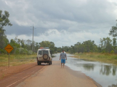
At last, a police 4x4 drives up to join the growing crowd of stranded motorists. The young PC is dressed in “Outback, wet season casual wear” - a T-shirt and a pair of baggy board shorts - the Creen Creek flood is becoming truly surreal. The policeman, Alwin, his teenaged neice and nephew and I, all wade out to the centre of the flood to assess the situation. The friendly constable advises us not to try and cross and then declares the road Officially Closed, though he says he can’t stop us from trying. He also says that there are definitely freshwater crocs in the area and Alwin says that the snakes are more a worry in the brown floodwater. I’m not fazed, it’s the big man-eating salties I’m scared of, but as my toes are becoming wrinkled from spending so long standing in the creek I quickly slosh back to dry road again.
It’s extremely hot and very humid and as the afternoon wears on, the two teenagers travelling with Alwin swim in the deepest part of the flooded road while the rest of us slouch around our vehicles smoking, chatting and watching the water level rise or fall against a stick that I poked into the mud. Then, the guy with the caravan on the opposite side of the flood starts up his engine and drives slowly into the flood waters. We watch with bated breath as the 4x4 and caravan crawl through the fast moving water. It looks like he is floating at one point but then he rises up out of the depths and is soon parked on our side of the creek with a smile on his face and water dripping from his rig. He had spent most of his time sealing all the gaps and crevasses on his caravan with gaffer tape and plastic. His wife and kids are all beaming smiles of relief while he goes about ripping the tape and plastic off. “Good luck, I’m out of here,” he says, and is soon a spec on the vanishing point that is the road east.
The Road Train (apologies for the jerky clip)
On the Road Again
We are standing about, egging the German chap to give it a go, when the ground begins to shiver, like a faint earth tremor. A low distant rumble rises out of the bush beyond the creek. It gets louder and the ground really is vibrating. Then, from out of the distance on the opposite bank a massive road train appears. It is my first road train and I am truly excited, like a kid looking at a big steam engine or a bloody great digger. The truck slows with a hiss and burble of brakes, then rolls and accelerates into the creek. A big, almost surfable, bow wave forms as the behemoth growls through the floodwater. The huge truck treats the water with contempt - like a tough kid in wellies stomping in a puddle. I want to cheer as the monster truck towing three long trailers roars past us, dripping water like Godzilla on wheels. I glimpse the driver, sitting up there in his air-conditioned cab, and offer him a casual but respectful nod of the head. He doesn’t even look down at us.
Soon, another vehicle, a sedan, drives up to the opposite bank and once again Alwin and I wade out to welcome the driver to Creen Creek. The new chum walks from his car into the creek and once in the centre sits down, fully clothed, then dips his head under. “That’s bloody better,” he says when he surfaces, “It’s fucking hot.” His name is Rodney, and he and his mate have travelled from Mt Isa, where they work, and are on their way to Innisfail. Rodney owns a house in the stricken town and wants to survey the damage. I advise him that the roads are all closed east of Mt Garnet, in fact the road is actually closed here at Creen Creek too. Rodney insists that he will cross this creek one way or the other, though he has no chance of driving across in a regular car. Even Alwin, my new aboriginal friend and expert on all things outback won’t attempt it in his sedan. Still, spirits are high now and we finally convince the German guy to give it a go. This gentleman and his wife are en route to a remote township called Bourketown, located a couple of hundred kilometres over unmade roads past Normantown. By the looks of things he is going to encounter a lot worse than this before he reaches Burketown, so come on mate... give it a go. He does and of course he makes it!
About in three in the afternoon we all agree that the current has eased a bit, though the water level hasn’t dropped at all. I reckon we can do it but I need the other blokes follow us across on foot to push us if we stall in the middle.
No good with cameras while under stress...
Get the camera ready... we're going across
“This is it Sheila. Get the camera ready,” I say. She gives me a contemptuous look, and says, “You know I’m no good with cameras when I’m under stress!” We fire up the engine and begin to creep along the submerged road. If the water is too deep the van could actually float and we will be washed over the causeway with the current, losing everything, possibly even our lives. If we go too fast, the water will well up and destroy the auto-electrics. If we go too slow we will stall. It’s an adrenelin rush that’s for sure, even though we are moving at just over one mile per hour.
We chug along, trying to keep in the middle of road by navigating between the top six inches of the white roadside posts. At the deepest point the current is fastest and the water wells up against the driver’s side door. Sheila is sitting with the camera clenched firmly between her legs saying “Shit Mike, Shit Mike!” I’m squeezing the life out of the steering wheel and clenching my buttocks so tightly that my head is touching the ceiling of the cab. We chug slowly past Rodney and Alwin and the teenagers who are still splashing about in the water. They egg us on with cheers and thumbs up. Then the road rises slightly and we are on dry ground again!
You have no idea how relieved we are at this moment. Looking back we can see our mob of roadside acquaintances splashing and waving to us from the brown water. I stop and get out to thank them and say farewell. Rodney assures us that the rest of the road to Normanton, about 120kms of it, is virtually flood-free. With no time to waste we toot the horn, wave goodbye and head off into the lonely savannah once again.
The road beyond Creen Creek is long, with endless vistas of nothing, and there are more shallow floods to cross. At one scary part we cross over a narrow bridge spanning a river that is literally a centimetre from flooding. There are mirages on the road ahead too. They look so much like real floods that we have to slow right down until they miraculously dissolve as we reach them. Every now and then blinding monsoons pour down on us, and at one point a large snake, slivering in the middle of the road, raises itself up to strike at our van as I swerve to avoid it. At 5.00pm we roll into Normanton. Never has a one-horse town looked so inviting.
Further information about the Savannah Way
- The Savannah Way - Cairns to Normanton Queensland section via Atherton Tablelands, Undara, the Gulf
Check out the official website for The Savannah Way.

