ArtsAutosBooksBusinessEducationEntertainmentFamilyFashionFoodGamesGenderHealthHolidaysHomeHubPagesPersonal FinancePetsPoliticsReligionSportsTechnologyTravel

Travel North - 60: Nidderdale Highs and Lows By Road

Updated on February 10, 2020

Vistas that never disappoint, villages and hamlets that reflect the history of the Dales...

Little Whernside not far to the north-west of Lofthouse in upper Upper Nidderdale. Ideal countryside to follow winding roads that seem to go on forever
Little Whernside not far to the north-west of Lofthouse in upper Upper Nidderdale. Ideal countryside to follow winding roads that seem to go on forever | Source
Great Whernside to the west of Lofthouse, seen above the tops - to the north-west of that, near the Settle-Carlisle Railway is Whernside, to the north of Pen y Gent and north east of Ingleborough (not a town, a mountain. The town nearby is Ingleton).
Great Whernside to the west of Lofthouse, seen above the tops - to the north-west of that, near the Settle-Carlisle Railway is Whernside, to the north of Pen y Gent and north east of Ingleborough (not a town, a mountain. The town nearby is Ingleton). | Source
If you think travel by car is too namby-pamby for you and you want to breathe in the air around you for longer, here's the map of the 4-day Nidderdale Way
If you think travel by car is too namby-pamby for you and you want to breathe in the air around you for longer, here's the map of the 4-day Nidderdale Way | Source
Close to the source of the Nidd is Scar House Reservoir, (hidden from view by the rise just above the image centre)
Close to the source of the Nidd is Scar House Reservoir, (hidden from view by the rise just above the image centre) | Source
Source
Upper Nidderdale, an area of outstanding natural beauty - AONB
Upper Nidderdale, an area of outstanding natural beauty - AONB | Source

Lofthouse-in-Nidderdale eludes many travellers who frequent the Dales, opting for better known Wensleydale and Swaledale. To many the roads up the dale from Pateley Bridge at the southern end of Upper Nidderdale and west from Masham via Fearby and Healey are largely unknown.. And yet it's equally accessible - albeit steep in places - from both directions.

Let's take the latter route, starting from Masham with its thriving market, two breweries and smaller market square cafes (did you put your coins in the honesty box when you parked?) We'll pass through Fearby first. Watch the road signs. Outsiders can get disoriented and they're not that large. The road is fairly easy on to Healey and then climbs up past the first of two reservoirs, Leighton. The smaller Roundhill Reservoir is passed next and you're still gradually climbing but it's not too bad even though there's a tricky twist past Leighton Reservoir. You come to the watershed between the two dales, Wensleydale with its largely wide vistas and Upper Nidderdale that seems to have been scooped out. The Ice Age glaciers bulldozed through this region (as it did further east through the North York Moors) in a bid to smooth out the landscape, sheering off smoother and softer rock formations, leaving the harder limestone prone to centuries of wear. You can see the nature of the environment in the building stone used over the last millennium.


See description below
See description below | Source

Compiled by a local socio-historical and environmental group, the Upper Nidderdale Landscape Partnership researches into the historical aspects of the dale as well as its natural and environmental history. You can't help but admire the professionalism of the book's presentation when you leaf through its pages.

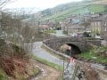
Lofthouse in Upper Nidderdale, North Yorkshire

A
Lofthouse-in-Nidderdale, North Yorkshire, England:
Lofthouse, Harrogate HG3 5RZ, UK

get directions

From Masham and Bedale in the Wensleydale direction, Lofthouse is ideally situated in Upper Nidderdale for exploring the Dales

Back a few miles towards Masham in Wensleydale

Leighton Reservoir and the River Burn
Leighton Reservoir and the River Burn | Source
The smaller Roundhill Reservoir, linked by a watercourse to Leighton Reservoir to the north-east, and ultimately the River Ure by Swinton near the market town of Masham
The smaller Roundhill Reservoir, linked by a watercourse to Leighton Reservoir to the north-east, and ultimately the River Ure by Swinton near the market town of Masham | Source
Lofthouse-in-Nidderdale looking downhill. The gradient towards Leighton Reservoir is steep and sharply winding, but only to the brow of the hill. It eases off and descends gradually - in places steeper - eastward through Healey and Fearby to Masham
Lofthouse-in-Nidderdale looking downhill. The gradient towards Leighton Reservoir is steep and sharply winding, but only to the brow of the hill. It eases off and descends gradually - in places steeper - eastward through Healey and Fearby to Masham | Source

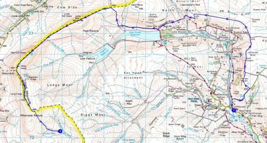
Scenically the approach from the north is better both for photographers and sight-seers. near Lofthouse, over the winding descent to Pateley Bridge you can see Little Whernside to the north (605 m) and Great Whernside (709 m) to the west above the hills beyond Middlesmoor and Stean below where the Nidd emerges from below Great Haw (544 m).

On towards Pateley Bridge are the hamlets of Ramsgill by the road, and Bouthwaite a short way further to the east above Gouthwaite Reservoir (all three reservoirs were created in the inter-war years to provide water for the West Riding mill town conurbations. Several farms and hamlets were evacuated when their dales were flooded.

Above the southern end of Gouthwaite lies the village of Wath, nestling in woodland to the east of the road. The narrow-gauge Nidd Valley Light Railway served the local communities and contractors' workers on the dams being constructed to hold the reservoirs, with stations at Lofthouse, Ramsgill and Wath on the way down to Pateley Bridge Station and the parallel connection with the regional network.

Down Dale towards Pateley Bridge

The road twists from Lofthouse downhill towards Ramsgill. Here is the view south over Ramsgill to Gouthwaite Reservoir
The road twists from Lofthouse downhill towards Ramsgill. Here is the view south over Ramsgill to Gouthwaite Reservoir | Source
Looking over Bouthwaite - to the east of Ramsgill - over Gouthwaite Reservoir (the dam built in the inter-war years for Bradford's water supply
Looking over Bouthwaite - to the east of Ramsgill - over Gouthwaite Reservoir (the dam built in the inter-war years for Bradford's water supply | Source
The expanse of Gouthwaite Reservoir, seen from the road to Pateley Bridge
The expanse of Gouthwaite Reservoir, seen from the road to Pateley Bridge | Source
The Gouthwaite Recervoir walk route - might take you most of the day, so book a room ahead
The Gouthwaite Recervoir walk route - might take you most of the day, so book a room ahead | Source
The Gouthwaite Reservoir Walk is undulating, to say the least. It'll give you an appetite for your evening meal - if you can last out that long
The Gouthwaite Reservoir Walk is undulating, to say the least. It'll give you an appetite for your evening meal - if you can last out that long | Source
Wickwood Farmstead near Wath, to the south of Gouthwaite - a thwaite is a forest clearing, (from the Norse) - across the River Nidd from the road to Pateley Bridge
Wickwood Farmstead near Wath, to the south of Gouthwaite - a thwaite is a forest clearing, (from the Norse) - across the River Nidd from the road to Pateley Bridge | Source
Wath Station on the Nidd Valley Light Railway that served the various communities of road and dam construction gangs
Wath Station on the Nidd Valley Light Railway that served the various communities of road and dam construction gangs | Source

It is thanks to this activity to update the water supply that the roads along Nidderdale were also impoved, both to serve the contractors and the communities. Thus an influx of tourists would result, although as I've mentioned not to the same extent as Swaledale and Wensleydale to the north.

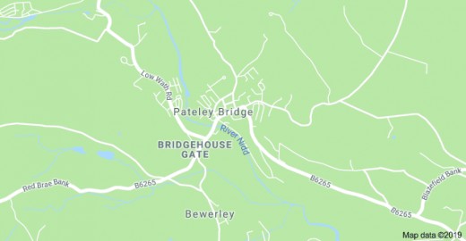
The market town of Pateley Bridge lies near the point where local roads intersect the B6265 that runs from Ripon in the east, and Harrogate to the south-east with its connecting B6165 from Ripley, between Ripon and Harrogate on the A61, to Grassington in Upper Wharfedale to the west.

Pateley Bridge, known locally as just 'Pateley' is a small market town with a population of just over 2,200 according to the census taken 2011. It lies within the Borough of Harrogate and belongs historically within the West Riding along with Harrogate and Ripon. Boundary changes in 1974 played havoc with the county and over recent years some changes have occurred that partially redressed the political machinations of Westminster. The West Riding was reduced to about 60% of its original size, bringing howls of protest from across the county.

With the oldest sweet retail outlet in the country - founded 1827 in a building that dated back to the 17th Century - Pateley also houses the Nidderdale Museum, that provides an interesting perspective of the dale's past. Also in the town, on the way out to Ramsgill, is the Foster Beck Water Mill, An inn now, with a large water wheel mounted on one end of the old building, it provides a point of interest for drinkers and alfresco diners on their way out of or into town. Close by, across the road is a large camping and mobile home park nestled amongst trees.

Yorkshire prides itself on its local and main county shows - the Great Yorkshire Show - that begin in late summer and end with the Pateley Bridge Show (a few days after the Stokesley Show this year) on 23rd-24th September.

Pateley Bridge

Nidderdale, market town at the 'throat' of  Upper Nidderdale. Undulating and hilly ground between here, Harrogate and Knaresborough where the Nidd follows through a steeply sided gorge
Nidderdale, market town at the 'throat' of Upper Nidderdale. Undulating and hilly ground between here, Harrogate and Knaresborough where the Nidd follows through a steeply sided gorge | Source
Pateley Bridge Station, opened by the North Eastern Railway to traffic in 1862, to close in 1951 after only 89 years of service to the community - the Nidd Valley Light Railway narrow gauge line went on from here up the dale (behind the photographer)
Pateley Bridge Station, opened by the North Eastern Railway to traffic in 1862, to close in 1951 after only 89 years of service to the community - the Nidd Valley Light Railway narrow gauge line went on from here up the dale (behind the photographer) | Source
Foster Beck Watermill, owned at the time of this photograph by Scottish & Newcastle Brewery (see the logo on the wall board, left). We stopped off here in the 1990s on our way north to Wensleydale. It was later a night club, now a private residence
Foster Beck Watermill, owned at the time of this photograph by Scottish & Newcastle Brewery (see the logo on the wall board, left). We stopped off here in the 1990s on our way north to Wensleydale. It was later a night club, now a private residence | Source

Let's dig into the town's history...

Pateley came under the auspices of the Diocese of the Archbishop of York, becoming 'Bishopside'. The main community of Bishopside in the 12th Century was nearby Wilsill, about two miles south-east of Pateleym recorded first as 'Patleiagate'. 14th Century versions show it - amongst others - as 'Patheleybrig[ge]'. The latter half of the name in the 12th Century derives from Old Norse and Northumbrian Aengle (Anglian) 'gata', meaning 'street'. The latter part, 'brig[ge]' stems from Old Norse 'brygge', perpetuated in local dialect meaning 'bridge'. The 'Pateley' part is thought to stem from Old English for a clearing oropen land, i.e. 'woodland clearing of [crossed] paths'. The 'paths' are now minor roads that cross just south of the town, the B 6165 and B 6265 that I've already pointed out. The 'Pateley' part of the name has raised debate amongst ethnologists. Another explanation dates back to 1227. The name 'Padtlewath' crops up, and the later 'Patheslayewath' from Middle English 'padil', and Old Norse 'wath' being one and the same, a shallow ford, reflecting the Danish presence of the 9th-11th Centuries. In 1320 the Archbishop of York awarded a charter for a regular market and annual fair.

Scotgate Ash Quarry operated above the north side of town from the 14th to the 20th Century, closing in 1915. Its hard-wearing form of sandstone was sent nationwide by train and applied as edge coping to station platforms, official buildings and seaport walls.

Foster Beck Water Mill, formerly a hemp mill. This Grade II listed building features a 34 ft diameter wheel at one end of the main structure. It has been an inn owned by Scottish & Newcastle Breweries, a night club and is now a private residence. The mill building has twelve bays of vertical oblong windows of sixteen panes each on the first floor, twenty panes each on the ground floor. Three end bays were added. Lintels are stone hammer-finished monolith stone, and both front and rear features are identical. Blocked windows on the wheel end wall suggest the wheel was originally smaller. It was worked as a hemp spinning mill by 1864 under the ownership of one Joseph Shann. The business was declared bankrupt in 1909 and bought by other operators, closed finally in 1966. The wheel you see on the building now, with its header tank were installed in 1904..

The narrow gauge Nidd Valley Light Railway used the terminus station of Pateley Bridge from 1907 to 1937, the standard gauge line closing in 1951. The line branched off the Leeds Northern line at nearby Nidd Bridge station, services emanating from Leeds Central Station terminated at Newcastle-on-Tyne. Connections could be made for trains to Harrogate, Northallerton, Eaglescliffe and Stockton-on-Tees. Currently the town's only public transport link with Harrogate is an hourly bus service up the dale.

Where is Upper Nidderdale and how do I get there?

From the West Riding conurbations, the Dalesbus route to Upper Nidderdale
From the West Riding conurbations, the Dalesbus route to Upper Nidderdale | Source
Upper Nidderdale in relation to the rest of the Dales region of Yorkshire, and where it fits into the 'jigsaw' of England
Upper Nidderdale in relation to the rest of the Dales region of Yorkshire, and where it fits into the 'jigsaw' of England | Source

If you drive from other parts of Britain or England in particular, the main road network centres on the M1, M62, A1(M), A65 and A66. Drive from Harrogate northward on the A61 to the Ripley roundabout, west along the B6265 Grassington road to Pateley Bridge, north to Lofthouse; from Northallerton west to Bedale and Masham beginning with the A684 to Bedale, the B 6268 to Masham and west via Fearby, the Leighton and Roundhill Reservoirs and over the watershed to Lofthouse.

By train to York, local train service to Harrogate via Knaresborough, Dales Bus northward. See routes above

© 2019 Alan R Lancaster

working

This website uses cookies

As a user in the EEA, your approval is needed on a few things. To provide a better website experience, hubpages.com uses cookies (and other similar technologies) and may collect, process, and share personal data. Please choose which areas of our service you consent to our doing so.

For more information on managing or withdrawing consents and how we handle data, visit our Privacy Policy at: https://corp.maven.io/privacy-policy

Show Details
Necessary
HubPages Device IDThis is used to identify particular browsers or devices when the access the service, and is used for security reasons.
LoginThis is necessary to sign in to the HubPages Service.
Google RecaptchaThis is used to prevent bots and spam. (Privacy Policy)
AkismetThis is used to detect comment spam. (Privacy Policy)
HubPages Google AnalyticsThis is used to provide data on traffic to our website, all personally identifyable data is anonymized. (Privacy Policy)
HubPages Traffic PixelThis is used to collect data on traffic to articles and other pages on our site. Unless you are signed in to a HubPages account, all personally identifiable information is anonymized.
Amazon Web ServicesThis is a cloud services platform that we used to host our service. (Privacy Policy)
CloudflareThis is a cloud CDN service that we use to efficiently deliver files required for our service to operate such as javascript, cascading style sheets, images, and videos. (Privacy Policy)
Google Hosted LibrariesJavascript software libraries such as jQuery are loaded at endpoints on the googleapis.com or gstatic.com domains, for performance and efficiency reasons. (Privacy Policy)
Features
Google Custom SearchThis is feature allows you to search the site. (Privacy Policy)
Google MapsSome articles have Google Maps embedded in them. (Privacy Policy)
Google ChartsThis is used to display charts and graphs on articles and the author center. (Privacy Policy)
Google AdSense Host APIThis service allows you to sign up for or associate a Google AdSense account with HubPages, so that you can earn money from ads on your articles. No data is shared unless you engage with this feature. (Privacy Policy)
Google YouTubeSome articles have YouTube videos embedded in them. (Privacy Policy)
VimeoSome articles have Vimeo videos embedded in them. (Privacy Policy)
PaypalThis is used for a registered author who enrolls in the HubPages Earnings program and requests to be paid via PayPal. No data is shared with Paypal unless you engage with this feature. (Privacy Policy)
Facebook LoginYou can use this to streamline signing up for, or signing in to your Hubpages account. No data is shared with Facebook unless you engage with this feature. (Privacy Policy)
MavenThis supports the Maven widget and search functionality. (Privacy Policy)
Marketing
Google AdSenseThis is an ad network. (Privacy Policy)
Google DoubleClickGoogle provides ad serving technology and runs an ad network. (Privacy Policy)
Index ExchangeThis is an ad network. (Privacy Policy)
SovrnThis is an ad network. (Privacy Policy)
Facebook AdsThis is an ad network. (Privacy Policy)
Amazon Unified Ad MarketplaceThis is an ad network. (Privacy Policy)
AppNexusThis is an ad network. (Privacy Policy)
OpenxThis is an ad network. (Privacy Policy)
Rubicon ProjectThis is an ad network. (Privacy Policy)
TripleLiftThis is an ad network. (Privacy Policy)
Say MediaWe partner with Say Media to deliver ad campaigns on our sites. (Privacy Policy)
Remarketing PixelsWe may use remarketing pixels from advertising networks such as Google AdWords, Bing Ads, and Facebook in order to advertise the HubPages Service to people that have visited our sites.
Conversion Tracking PixelsWe may use conversion tracking pixels from advertising networks such as Google AdWords, Bing Ads, and Facebook in order to identify when an advertisement has successfully resulted in the desired action, such as signing up for the HubPages Service or publishing an article on the HubPages Service.
Statistics
Author Google AnalyticsThis is used to provide traffic data and reports to the authors of articles on the HubPages Service. (Privacy Policy)
ComscoreComScore is a media measurement and analytics company providing marketing data and analytics to enterprises, media and advertising agencies, and publishers. Non-consent will result in ComScore only processing obfuscated personal data. (Privacy Policy)
Amazon Tracking PixelSome articles display amazon products as part of the Amazon Affiliate program, this pixel provides traffic statistics for those products (Privacy Policy)
ClickscoThis is a data management platform studying reader behavior (Privacy Policy)