- HubPages»
- Travel and Places»
- Visiting Asia»
- Southeastern Asia
Volcanic Destinations in Java, Indonesia.

The location of Indonesia in the ring of fire is related with volcanoes existence in the country which gives not only potential disasters but also landscape attractions and other invaluable benefits for agriculture, national economy, tourism, and even medication. Some volcanoes on Java island that I have visited are :
Mt. Tangkuban Perahu
Mt. Bromo
Mt. Patuha-white crater.
Mt. Dieng
Mt. Papandayan
Mt. Merapi
I've written my experience visiting the first two volcanoes Tangkuban Perahu and Bromo in previous hubs and now I'd like to share the other volcanic destinations which each of them always presents particular uniqueness and attractions.
- Visiting Bromo in Frugal Traveling.
Bromo mountain is one special destination which has become the icon of East Java. This destination has attracted people from all over the world and here my experience in visiting it in frugal traveling. - Visiting Tangkuban Perahu-A Legendary Upturned Boat ...
Besides its function as a tourism area, Tangkuban Perahu is part of West Java cultural heritage since the history and legend behind it is anchored to the life and formation of areas in the province.
Ring of Fire.
A ring of fire is an area where earthquakes and volcano eruptions frequently occur because of the presence of active and dormant volcanoes in the area.
The existence of volcanoes give some benefits besides their danger and other unwanted effects:
The benefits :
- Volcanic ashes spewed from the eruptions contain a lot of useful minerals so that they are good for plants growth. The further result is that volcanic ashes cause agricultural programs to be more intensive and extensive
- Volcanic eruptions also gush other materials like sands, gravels, rocks which become important materials in development.
- Lava flowing out of the crater brings out mining materials like iron to the surface and make it easier to be mined and explored.
- Volcanoes have function in creating orographic rains which are only possible because the volcanoes catch the humid clouds to fall as rains.
- Volcanic mountainous areas have fresh air, beautiful view and have potentials to be developed for tourism, medical purpose like sanatorium, rest areas, resorts , etc.
Some disadvantages caused by volcanoes :
- Massive danger caused by its eruptions take numerous victims and colossal impacts.
- Hot toxic gasses are spewed from volcano eruption.
- Incandescent lava mixed with the fluid in the crater flows down the caldera in the form of dangerous hot lava crashing everything down on its way.
- Accumulated lava in the mountain crater can change into cold lava landsliding the area below it when the eruption takes place.
- High, vast mountainous areas create rain shadows and cause less rain intensity as well as make the area arid.
- There were many cases when the volcanic earthquakes caused huge, deadly tsunamis.
- Volcanic ashes in the air also endanger aircraft and air transportation.
Other Volcanoes :
Mt. Patuha-White Crater.
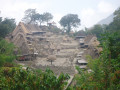
To reach Mt. Patuha with its White Crater, we need to go to Ciwidey first. Ciwidey is located in a highland which forms Mt. Patuha in the south of Bandung. This hilly area has pretty landscape decorated with lush, vast, carpeting tea plantations. The combination of some attractive places at Ciwidey and enjoyable atmosphere have made Ciwidey a favorite destination for Bandung people as well as other people from neighboring cities to visit.
Ciwidey is connected with Bandung by a smooth road, so we can can drive or ride motorbikes around 55 km away to southern Bandung, or take a public transports with Ciwidey destination from Sasak Panjang bus terminal in Bandung (the biggest and the capital city of West Java).

Mt. Patuha (2434 m asl) has two craters, one is at its peak called Kawah Saat (Dry Crater) and an iconic crater named Kawah Putih or White Crater located to the west below (2194 m asl). Kawah putih, as the name refers to, is always blanketed with sulfuric deposits which gives white look to the crater and invites million of people to come. They mostly visit the crater for three main purposes :
- Enjoy the beauty and the fresh air (although its freshness's often 'disturbed' by the sulphur smell in the air),
- Get the sulphuric deposits for skin medication, and....
- Take pre-wedding photos for marrying couples.
Both craters were formed during Mt. Patuha eruptions in X and XII centuries.
The White Crater was full of mystery when a lot of birds and some people found dead after flying above the crater or after spending sometime near the crater rim. The incidents made local people believe that powerful spirits live there and they didn't like their authorities to be disturbed. The mystery lingered for quite long time and avoided them from visiting the crater until 1837 when a Dutch scientist DR. Franz Wilhelm Junghuhn came to Patuha. His inquiries had given the scientific explanation that the series of death were caused by poisonous gas released from the crater.
With less poisonous gassed emited by the mountain today, Mt. Patuha has become a favorite place although alertness must be maintained since Mt. Patuha is an active volcano and some parts of the places there still produces gaseous poisons.
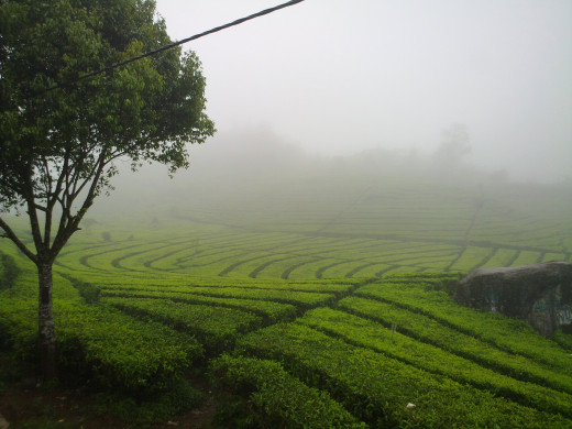
The land around Mt. Patuha is very fertile and the best place for tea to grow.
Vast, lush tea plantations are seen and dominate the view, spread widely and well pruned in attractive patterns. The patterns applied to the plantations by skillful hands have created wonderful view and made them among the most scenic tea plantations in Indonesia.
The tea plantation areas at Ciwidey are devided into 4 sections Rancabali, Malabar, Pangalengan, and Gunung Halu. They are considered the oldest plantations in the country, which have been planted for more than 143 years.


Could I have your opinion on
How you like mountain climbing and trekking ?
D i e n g.
Dieng is a giant mountain with several active craters are found in there. Dieng highland areas belong to two regencies : Wonosobo Regency and Banjarnegara Regency, Central Java, and located at 2000m above sea level.
Being a giant mountain, Dieng has at least 5 main craters which are kept on under monitoring of Indonesian Center of Volcanology and Geological Hazard Mitigation due to their unceasing activities. Those 5 main craters are Sikidang, Sibanteng, Sileri, Sinila, and Timbang.

Sikidang :
Sikidang is the most popular crater at Dieng. People name it Kidang (deer) for its keep-on-moving crater location like a deer agility.
Located at marshy, hilly areas, Sikidang is the one with the easiest access to reach. We can watch the bubbling magma with its rumbling sound just some meters away from the magma center. A warning notice stands near the crater rim to remind visitors on the danger condition and not to go beyond the rim.
There is a market prior to the entrance where sellers offer various souvenirs including sulfur rocks which are packed in small plastics.
Dieng always gets special attention :
Dieng is very active and often shows surprising volcanic activities. The last alarming movement was in March 2013 when some earthquakes happened and caused emission of CO and CO2 gasses from some of the craters. Timbang and Sinila are among the most active craters and special attention is always paid by PVBG (Indonesian Center of Volcanology and Geological Hazard Mitigation) to them so that prompt warning can be released when Dieng craters show extraordinary activities.

Dieng cultural sides.
Dieng is rich of cultures and has a lot of traditions. As the name regards, Di means Candi or temple and Ieng is Hyang means God, so Dieng is a land where Gods stay. As a matter of fact many temples are found at Dieng although Muslims are dominating today. The spread locations of Hindu temples prove that Dieng history dates back to the golden era of Hindu kingdoms in Java. Those temples were given names from Pandawa family in Mahabharata epics like Arjuna, Gatotkaca, Srikandi, Semar, etc.

Dieng Culture Festivals
In Dieng Culture Festivals, ceremonies are regularly held annually with the main location at Arjuna temple and normally take place for 2 days.
On the first day, some arts and Javanese dances are performed including lantern festivals where colorful paper lanterns are prepared and fly to the sky. This will create skies look wonderful decorated with blinking lanterns. Still on the same day, the steer puppet performance is also on the show around the clock. This is a favorite show for Javanese of all ages and they are willing to stay all night long to enjoy the show locally named Wayang Kulit (Javanese leather puppet show). Food and souvenir stalls also take advantage of this special occasions, giving them extra profits which they don't get on regular days.
Dreadlocks hair ceremony.
There are children at Dieng who are considered special. They are endowed with dreadlocks hair which grow naturally and the respectable Dieng elders regularly hold a sacred ceremony for them which is usually performed in mid year between late June and July. The dreadlocks children need to be given sacred ceremony for some reasons :
- Dreadlocks children are considered the representatives of Kyai Kolodete, the ruler of Dieng.
- Dreadlocks hair may bring bad luck, so it needs cutting.
- The dreadlocks hair cutting without prior ceremony will make those dreadlocks-haired children get sick and their hair will return dreadlocks.
This ceremony is very attractive and many people, local as well as international, will come to follow the ceremony in person.
Mt. Papandayan
My excursion to Mt. Papandayan took place years ago when my adventurous enthusiasm was very strong and needed to be channeled. I went there with some friends of my age and enthusiasm and started the journey from southern Bandung, the capital city of West Java Province.
Bandung is geographically situated in the middle of a big valley with active mountains surround it from all directions. Stretch in the north of Bandung a row consisting of Mounts Burangrang (2064 m), Mt. Tangkuban Perahu (2084m), Bukanegara, Mt. Bukit tunggul (2209), Mt. Palasari (1600m), and Mt. Manglayang (1818m), the row in the east are Mt. Bukit Jarian, Mt. Geulis, Mt. Dusung, and Mt. Kendan.
In the south there are Mt. Mandalawangi, Mt. Rakutak, Mt. Malabar, Mt. Patuha, and Mt. Kendang some in the far south are Mt. Guntur, Mt. Cikuray, and Mt. Papandayan (2665m). Another row in the west are Mt. Selacau, Mt. Lagadar, and Mt. Bohong.
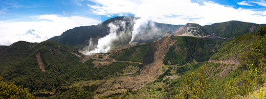
Papandayan is located 70 km away to the south of Bandung, under the administration of Garut Regency.
This mountain has some tracks for people who want to visit it. Those who want to come in a leisure way can go there by car or motorbike and park it at a provided parking lot. From the parking lot they need only some minutes walk to go to the first crater, Kawah Mas.
Another, more challenging track for those who want to enjoy Mt. Papandayan as mountain climbers, is available through the other side of the mountain and take around 6 hours to reach the peak. Papandayan true peak is actually called Mount Malang which is around 140 m above Papandayan peak (2665m) but in addition to its very hard route with no marked spot as guidance, mount Malang is covered with very dense vegetation that trackers are reluctant to reach it and there has been no official publication about successful tracking having reached the Malang peak so far.
Trekking path to Papandayan Peak.
The trek to the peak is divided in the following parts :
To reach Papandayan first you need to go to Garut, around 3 hour drive by car or bus from Bandung. We continue the ride to Cijulang, a small town around 30 minutes drive from Garut. At a village named Cisurupan, we'll need to turn left and a Papandayan welcoming board to its visitors will appear not long after that. There you'll find a parking area as the base before continuing to the next route.
Parking Lot - Pondok Salada.
Pondok Salada can be reached through a foot path not far from the parking area. The foot path leads to Kawah Mas (Golden Crater) which has some soft grounds with hot temperature beneath. We have to watch our steps when we cross the crater in order not to step on the wrong
Pondok Salada - Alun Alun Tegal Alur.
The next trip from Pondok Salada is going to Alun Alun (square) Tegal Alur through a steep path which needs us to be very careful on a deep ravine on the left side and light forest around also makes us to be more cautious.
After passing not so dense forest, we'll come to a land seems like a dead crater which continues to a wide open area locally called Alun Alun Tegal Alur. Tegal Alur is a grassy meadow with many open plains to make them ideal for camping. It's nice to camp here although it must be done with care considering that it is wild boars and dogs' ranging area. Thrashes and food remains shouldn't be thrown carelessly if we don't want to invite those beast to be around our tents.
Somewhere at the far end of the Alun Alun (means open space), flows a small river with cold, clear water runs in it.
Alun Alun Tegal Alur - The Peak.
To continue the trekking to the peak we need to go crossing the river since the next path is at the other bank of the river. The track is physically not so conspicuous due to bush covering and to help trekkers find their way, there are some color ribbons knotted at some trunks as guidance.
Beautiful views overlooking the car park, Pondok Salada, and white smokes billowing to the skies from active craters are seen below. At certain elevation we are even sometimes able to see the south coast of Java down far away. It takes around 90 minutes to reach the peak from Tegal Alur.
The summit of Papandayan is signed by a small white flag and if you keep on moving down for around 200 m from the peak, you'll see a better view of Papandayan crater and its caldera. If we're lucky enough, we'll also spot some birds including predatory avian among the rocks.

Mt. M e r a p i
One of the most active mountains in Indonesia as well as in the world is Merapi. The name Merapi (means Mountain of fire) refers to its continual eruptions not less than 100 times since 1548. The mountain used to be officially recorded 2968 m with the highest peak popularly known Puncak Garuda (Eagle Peak) due to its eagle-like shape but after big eruptions in 2010, Merapi has elevation 2930 m above sea level.
Located between two provinces Yogjakarta and Central Java, we can climb Merapi from either Kaliurang area in Yogjakarta or from Selo village in Boyolali, Central Java. Climbing route from Selo is more recommendable since it has gentler track with a post facilitated for climbers called New Selo and the climbing entrance just around the corner.
I myself did this Merapi climbing with a friend from Selo also because of above reasons and other considerations recommended by cyber friends who had been there before.

Selo is a village under administration of Boyolali regency around 25 Km from Solo or Surakarta city.This village is located at the slope of Merapi foot around 1500 m above sea level. Making some preparations at Selo before the climbing is good for acclimatization. You can also see the the checkpoint near Selo intersection to get the climbing permit.
Climbing Merapi from Selo takes around 4-5 hours in normal speed and a strong climber can even do it in 3 hours to reach the mountain.
Selo people generally lead prosperous life and many of them have source of income as farmers growing tobacco, vegetables, and chives. They also raise cattle like buffaloes, cows, and poultry as additional income besides their farming activities so that they can get compost for their farm made from the dungs, own motorcycles as their means of transportation and even send their children to neighboring big cities for higher education. The family where I rent the home stay also has a home business making traditional food and crackers which make them possible to fund their 2 daughters' education in nurse college and senior high school, including paying their boarding house in Solo.


People like to start to go up to Merapi at around 12 at night in the hope to witness the sunrise at the peak of the mountain within their 5-hour-ascending time.
Torches with at least 5-hour-battery life, mask, gripped and strong-but-light shoes, cotton gloves,two litters of fresh water, some snack and sweets are important to bring. Wearing mask during the climbing in dry season is necessary since the foot steps make dusts on the paths will easily fill the air.
Water supply is not available so make sure the water you bring is enough for back and forth journey of your trekking.
To reach the top of Mt Merapi after Pasar Bubrah (Dismissed Market), we must face a vast open area which is covered with seas of sand, gravels, and sharp rocks, so wearing open shoes is not recommended although they are lighter but those shoes will risk your toes and expose them to small rocks which I found very annoying.

Cultural events at Selo.
If your visit to Selo happens to be one or two days before the 1st Suro, the Javanese New Year and considered sacred, you might be lucky to see some cultural ceremonies there in the new year's eve.
The local authority will close the climbing track to Merapi for Upacara Peringatan Satu Suro (the commemoration ceremony of the 1st Suro ) to take place .
Upacara Peringatan Satu Suro is an important ritual for Javanese people in rural areas who still hold old tradition dearly. The around-the-clock festivity is a symbolic ceremony in expressing their gratitude to God Almighty for all blessings, gifts and protection that God has poured and almost all places considered sacred hold the ritual annually.
The ceremony is filled with some processions :
- Starts at 8 pm at Lencoh, Selo Sub District. In this session, guests are treated with opening shows like traditional dances and performances.
- Chanting Legenda Gunung (Mount Legend) and prayers by the elsders in order to bless various offerings people have prepared in the forms of food, vegetables, fruits, various produces, not to mention the compulsory offering: A bull head. .
- Parade all the offerings including the bull head to be offered to god at the peak of Merapi. If the condition doesn't allow them to go up to Merapi and Merbabu peaks due to increasing crater activity, they'll stop the procession at Pasar Bubrah and plant the bull head at one spot there. All people participating in the processions will compete to get any parts of the offerings at final step and climax of the ceremony with the hope to get the blessings contained in them.