- HubPages»
- Technology»
- Computers & Software»
- Computer Software
How to See Street View in Google Earth using iPad,iPhone & PC
Google Earth's popuraltiy skyrocketed ever since they introuduced street view facility. You can visit any street of the world with just a few click. This post aim to help you to see street view in your PC or mobile phones. Rememebr that for each device( let it be a laptop, ipad, iphone or android ), you need to follow specific set of intructions in order to see streebe level images.
No matter which device you want to use to seet street view, you have to follow to generic steps:
- install the Google Earth.
- Enable Street view
Backgound : before showing you how to find a street view in Google earth, let me explain a little history of this stunning earth viewing software. Google earth is a virtual globe map, which is equipped with necessary geographical statistical data and videos of our planet earth. Initially it was known as earth viewer, designed by keyhole Inc. In 2004 Google acquired keyhole, Inc. and since then Google has been developing this software. Many people around the world use Google earth to learn about streets and addresses of foreign places. Before visiting a new place, you can easily get an overview of the place and also can find any particular street-view along with details geographical data - mostly tourists use it before traveling to a new place.
Not many people know that there are some other versions of Google Earth apart from the free edition available to anyone on Internet. The commercial versions of Google Earth is known as- Google Earth Pro and Google Earth Enterprise (the most advanced version). Of course, these two products have some extra features and functions, over then free edition, for viewing any particular street of our planet.
How to enable street view in Google Earth?
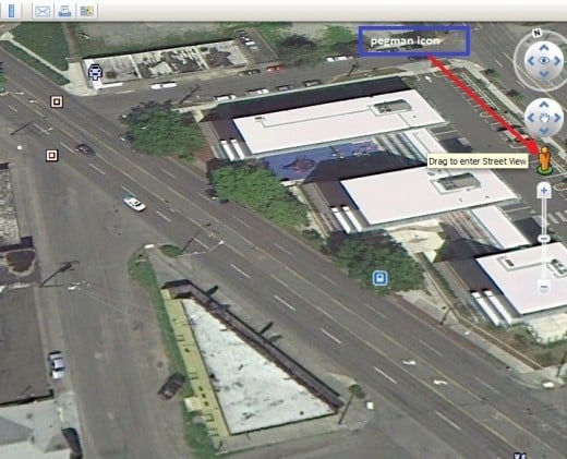
Both Google Earth and maps offer street view.If you like to see street photos in Google Earth version 6, then you must enable it by dragging the pegman icon on your map-that is all you need to do to see street view of your places.
How to see Street view in iPhone,iPad?
For iPhone,iPad,iPod users willing to enjoy street view features need to download the mobile Google Earth version at first by going at : Google Earth Mobile . Once you visit this page you will see a download link that will direct you to iTunes page.Just download the iTune 10.If you already has iTunes, then click on the tab "I already have iTunes" and start downloading Google Earth app for free.Once you finised downloading and installing this app, you can use steet view feature the way you see it in your Laptop or PC.
Google Android users can download Google Earth from the link page I provided above.Or the easiest way to download Google Earth in Android is to send this link- Android app for Google Earth-on your mobile phone and then click on it.
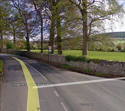
Pegman Icon in Google Earth Street View
Try Street View of Paris in Here Right Now
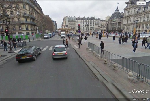
To enjoy the street view of Port De La,Paris, France, Just drag the pegman icon(man like icon), on the left top of the above map,on the location "A"
Street View of Zurich, Switzerland
To move around the streets of Zurich simply drag the pegman icon in the location marked with "A" on the above map.
Google Earth 6
In new Google Earth 6, street view has been integrated with the 3D view. If you are browsing the Map and want to see street view, then pick the pegman icon , on the right side(just below navigation control). Put the pegman in the street map where roads are shown with blue lines. Remember roads shown in only blue lines are available in street level imagery. To move around the streets use your mouse button or just scroll it. If you are not familiar with how to look around the street level in Google Earth, just explore the entire button and scrolling option in your mouse-it’s really a fun!
Set up Street View in PC
To see the street view start the Google earth software for the first time in your computer, you will see a globe. Now, For street view, just go to the left-bottom side tab of the Google Earth, Layers, and in the Layers section you will see a box called “street view”-click it to enable the street view. Using mouse, you have to point to any country or location where you want to visit and double click your left mouse button to magnify the globe, magnifying is also possible by scrolling the mouse forward. A single left-click will stop magnifying the globe. In the way of magnifying if you see the name of the city you are looking for, just double click the city name and enter the city map. Over the city map, you will find many cams like icons, move your mouse pointer in any of the icon and it will show you the street address. In the address window, click the “jump into the street view” and view the street. Now, keep virtually moving on the city with clicks of your mouse-that’s how you can view any street in Google Earth.
Street View UK
If you want to find any particular area or address, then the easiest way to get it is to type the name of the area in the top-right side search box “Fly To”of Google earth, instantly you will see that area in your computer screen with all the details including longitude and latitude. Now, what you have to do is to move your mouse through the streets and keep magnifying the image by clicking to get a clear picture of the streets.
How to find a particular street address in Google Earth-For example, you just want to find any restaurant in Glasgow, UK. Then in the search option of Google Earth select the “Find Business” tab and in the “What” field type restaurant and then in the “where” field type Glasgow and click the search button- the search result will give you a number of restaurant addresses in the left pane. Double click in any one of the addresses; this will give you the detail map of the restaurant, shown on the right-hand pane.
Google Earth Pro
Free Google earth version offer printed image resolution of 1000 pixels only. In case you are looking for more high resolution printed images for your business, then you can thinking of buying a commercial version of the software-Google earth Pro- it costs $400. The benefits of this version is much higher printed picture resolution of 4000 pixels, GIS data importing for creating map, addresses mapping in spreadsheet tool, making custom video using the movie maker. Once you have licensed version of Google Pro, you will have the all the necessary rights to access Google images for your business and marketing purpose, as long as you don’t sell your data to any third party company.
Street View in Google Earth
Changing Language Settings
Google earth software supports most of the popular international languages. To change your language setting you need to go to the main menu bar, click tools and then option. In the “Google earth options”, you need to click the “general” tab and then from language setting, select your preferred language and click the apply button. To take effect the language changes, you have to restart the software.
Historical Imagery in Google Earth
Google Earth Enterprise
If your organization need to handle large amount of geospatial data, then Google Earth enterprise has it all you need. It has the capacity to handle extremely large quantities of data and can be an extremely cost-effective solution for your need to access geographic information system (GIS).
Some Exciting Features of Google Earth 5.0(older version)
Most of the people only use Google earth for just finding location or getting geographical images of the world. But other than finding location, you can virtually visit under water or even take a tour in Mars. Google earth also offers virtual tour recording option, for example you can record your all the actions and movements, while you are using this software. In fact, there are many more options to explore in Google Earth, the best way learn about it is to keep exploring all the functionality of the “layer section”.
Google earth is not all about street view, it is full of lot more functions and features like- viewing the most important historical places of the planet, viewing ocean, weather and lot more. Yet, the functionality of the street view is one of the fascinating and popular functions of Google Earth. To have a more vivid view of your neighborhood, check out the Google Earth Street View functionality-it’s a very easy-to-use and fun function indeed.
Google Earth Street View under Privacy Violation Attack
Due to providing street view option to its users Google has already faced a couple of objections. One of it came from German authority, while Google was capturing street view data with its cameras; they accidentally captured user’s data of Wi-Fi networks. The most recent accusation of collecting unauthorized came from the South Korean cops. However, street view is a fantastic feature and one of the most popular services enjoyed by millions around the world. The problem of collecting unauthorized data can be easily overcome if Wi-Fi Network Company uses encrypted form of data. Keep enjoying the street view ..
How to Record a Street View Tour in Google Earth?
When you move across the streets in Google, you can record your tour in Google Earth.This is very useful feature, because this recording option will give you the opportunity to watch
the streets again and again without going online.Once you save a street view tour,it will be saved in your local hard drive and you can access it from the "places" panel of your Google Earth. Okay, let me show you how to record a tour.At first you need to go the street and then before moving around the streets, you need to click on the camera icon "record a tour" on the top of your Google Earth. This icon looks like a camera with a plus sign on it and when you take your mouse on it, it will show "record a tour"-just click on it.Now start the red color button at the bottom to start the recording.Just follow the white lines on the streets or go anywhere you want and when you want to stop the recording, click on the red-button once again and then click on the save button,at the end of the recording bar.Now, you can name it and save it by clicking OK.This new tour record can be accessed anytime from the places bar, on the left column. To view a recorded tour click on the name of the record name of the street view under the places bar and then click on play icon, at the bottom on the map.
Street View with 3d Trees and Buildings
The new Google earth version 6 will let you view a few cities( San Francisco, Chicago, Athens . Amazon rain forest) with 3D buildings and Trees.Unlike Google maps 3d, you can not directly enable this 3d view with Google Earth 6.To see 3D view on your Earth software, at first you need to go to the street view.For example, you wan to see San Francisco in 3D. and for that you have to select the 3D buildings in the layers tab(on the left side column). Under the 3d building option, you might select "photo-realistic" option along with "Trees" in order to view the city in 3d street level with trees and buildings.Now, click on "Exit street view" to roam around the city with 3d trees view.
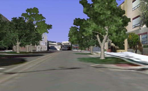
How Google Turns Photos into Seamless Street Views?
When Google car drive down the roads they simply collect images and location information. To keep the images seamless along the roads, they use a number of overlapping cameras so as at the and all the pictures taken can be stitch together for smother transition. Google state-of-the-art image processing technology to join images without distorting the aesthetic view of the photos. Afterwards all the images along with its longitude and latitudes are put together to give you a feel of smooth surfing through your familiar streets in your desktop. For your information, the street view images you see are not real time. Depending on the places, it can be a few months to even a number of years old.
Privacy Issues and Reporting Problems
All the images you see in street view are collected by driving car equipped with GPS and recording devices. If you are using street view option since the beginning of its launch back in 2007, you might have noticed that in recent images both human face and car number plates are blurred. This is because of privacy issues. Google use the face recognition technology to identify and blur faces so as you can protect your privacy even if you are framed while Google car collecting the street view imagery. If you are not satisfied with the level of blurring, in case you are framed, then you can request Google to blur more of your photo. To do that, go the location of the street view where you are visible and then on the bottom of the street view window you will see an option “report a problem” and fill the necessary options in order to Google taking necessary action to protect your privacy or any other problems.
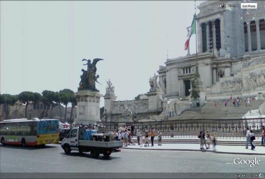
Steet view of Historic places in Italy
Via Celio Vibenna, Rome, Italia
Makena road of Hawaii Beaches
Street of Hawei Beaches.6681 Makena Road, Kihei, Hawaii, United States
Street View of Hiroshima Peace Memorial
How to enable street view of Amazon rain forest?
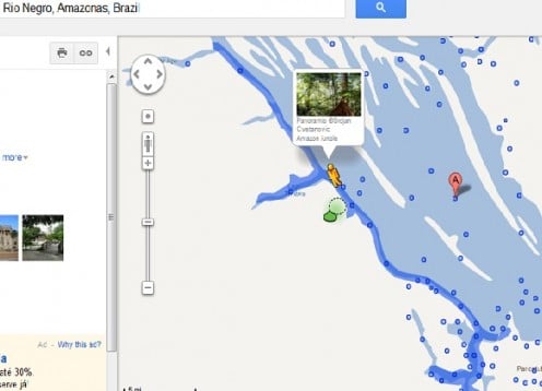
On March 22,2012 Google has made available part of Amazon rain forest in their Google street view program.Now, you can easily fly around Rio Negro River with the help of Google Maps. if you have not browse the street view of this breath-taking Amazon rainforest, then you might do so by going at Google map and then type the following on the search bar.
Rio Negro, Amazonas, Brazil
Drag the pegman icon Near the Rio Negro river,where you will see a thick blue lines.Release the icon over that line and watch street view of that river. you can cruise across the river deep inside Amazon if you search for Rio Negro School, near to Ligo Timbire, and the put your pagman close the the blue lines to that school.
How to find Street View of Amazon Rainforest
How to see ground level view?
The places that has yet to be included in Google's street view database can viewed from ground level.To enable ground-level view, keep zooming on Google earth until you see a pegman icon. Next, drag the icon to the place that you want to see with ground-level view.
If you want to know about the street view technology and its development timelines and history then you can find this information in Wikipedia page on street view.There is a good news for Indian Google users who would love to explore their cities with Google street view, Google has already started its work of gathering street view images of one Indian city, Bangalore.Hopefully, shortly we will be able to enjoy the streets of Bangalore.


