Granite in the Sandia Mountains


Abstract
A road cut on the east side of the Sandia Mountains, in central New Mexico, exposes enough Sandia granite and the Sandia Formation to provide evidence that weathering along the Great Unconformity is taking place at various rates. The percent biotite and grain size in four different weathering ranks were used to determine granite composition at different states of weathering. The results yielded the interpretation that granite contains more biotite when it is fresh and the biotite weathers out with time. In addition, the middle ranks of granite weathering do not show significant variations in percent biotite from one another. The various states of weathering and their percent biotite values have led to the conclusion that biotite composition is a good indicator of how weathered granite is. In addition, tectonics in the area can explain the fractures and joints that give the granite blocks their shape. Tectonics and weathering of the Sandia Formation limestone also explain why some portions of the road cut are more weathered than others.

Hub on How to Write a Scientific Paper
- How to Write a Scientific Paper
Outlines good practices while writing college essays for sciences courses or scientific papers for publication.
Introduction
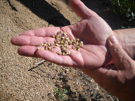
A road cut along New Mexico Highway 536 on the east side of the Sandia Mountains exposes Sandia granite and the Great Unconformity at the Doc Long Picnic Area. The Sandia granite underlies the Great Unconformity and the Sandia Formation, comprised of sandstones, shales, and limestones overlies it. Although granite is highly resistant to weathering, in this area, granite is found in various states of weathering, from granitic corestones to grus, as seen in Figure 1. It is interesting to note that the road cut has only been present 60-70 years and grus has either already been formed or grus that was already present 60-70 years ago now mantles the road cut. Also, corestones are permeated with fractures and/or joints that are both vertical and horizontal. These features appear to hold more information on weathering happening around and within the granite. The weathering, or lack thereof, of granite and, in particular, biotite in the granite may also provide more evidence as to how weathering is occurring in the area and at what relative rate.


Another Geology Hub
- Indigenous Paleosols on the Jicarilla Apache Reservation
A scientific study on soils in northern New Mexico.
Field and Laboratory Methods
Several different small sites approximately 30 x 30 cm in area were observed in some detail. Each site was assessed by its weathering rank, mean grain size, biotite percentage, and anything noteworthy, such as rock type and mineralogy. The weathering rank was determined auditory by striking the outcrop with a rock hammer and deciding whether the sound was a sharper “clink” or a dull “thud,” as seen in Figure 2. Sharp “clink” sounds were given a weathering rank of 1, indicating that it is a fresher corestone rock and dull “thud” sounds were given a weathering rank of 4, indicating more highly weathered or grus-like material. Sounds in between weathering ranks 1 and 4 were given ranks 2 and 3 accordingly. Mean grain size was determined by approximating an average grain size at each site using a millimeter ruler, provided in the lab handout. And, finally, biotite percentage was determined by comparing biotite in the rocks to illustrations of percent biotite in the lab handout.

After all observations in the field were made, the class’ group data was compiled into an Excel spreadsheet. The data was then manipulated into a table, Table 1, to illustrate the different values and histogram representations of mean grain size and percent biotite in each weathering rank, Figure 3, and the frequency of percent biotite class boundaries in weathering ranks, Figure 4. Figures 3 and 4 will be discussed later in the paper. In addition, a t-test was performed to determine whether or not there was a significant difference between mean values, this will also be discussed in detail later in the paper.
Scientific Hubs
- Do You Know What Else Crude Oil Makes?
If the first thing you think of when you think crude oil is gasoline for your car, you might want to consider that crude oil is a crucial component in making these far more essential products. Simply reading the paragraph titles will give you a bette - Do You Know What Peak Oil Is? If Not, You Should
For many decades, there has appeared to be an unlimited supply of oil but, like all good things, its time will come to an end. - You Are Currently Moving at about 1,000 mph!
Have you ever wondered how the Earth moves and you can't even tell. This hub will explain why. - Ever Wonder What is in the Air We Breathe?
Imagine constantly breathing in harmful toxins. Now imagine breathing nice, clean air. Do you know what is in the air you breathe? The air you breathe makes a BIG difference. - Predicting Future Sea-Level Change
Find out how monitoring present sea-level is used to understand and predict future sea-level change as Earth’s climate is also changing.
Grain Size Distribution
Sandia granite is mostly composed of feldspars (mostly potassium feldspar and plagioclase), quartz, and biotite in various percentages and grain sizes. Figure 3 illustrates a comparison between mean grain size and percent biotite for the different weathering ranks. The mean percent biotite decreases as the granite is weathered. In contrast, the mean grain size does not appear to have a trend. The error bars in the histogram represent the standard deviation of mean grain size and percent biotite for each rank. The error bars for the standard deviation of mean percent biotite are mostly above the mean percent biotite, except for in weathering rank 4. The error bars for the standard deviation of mean grain size are also mostly above the mean grain size, except for in weathering rank 2 where there is also a larger mean grain size than any other rank. The closeness of the error bars to the mean values indicates that the mean values are a fairly good approximation of the mean percent biotite and mean grain size in each weathering rank.

Interpretations
In addition to comparing mean grain size and percent biotite the values for percent biotite were categorized into class boundaries according to their frequency, as seen in Figure 4. The overall distribution can be very loosely interpreted as a bell curve; however, there is at least one major outlier. The frequency for percent biotite in the class boundary of 5 for weathering rank 1 greatly exceeds the expected value. This outlier could be a mistake in data collection or data compilation, or, most likely, it represents the high biotite composition in the fresher granite that makes up weathering rank 1. Weathering ranks 2 and 3 are shown to have continued medium percent biotite composition. Weathering rank 4, however, has greatly diminished values of percent biotite and frequency. This is to be expected though because the biotite is being weathered out of the granite and grus over time.

Hubs on "The Control of Nature"
- Cooling the Lava: The Battle to Save Heimaey
Read about the terrifying ordeal of waking up to an active volcano erupting just outside your front door and how a town was sacrificed. - Controlling Nature?
A look at John McPhee's several examples of failed attempts to control nature in "The Control of Nature." They are given to illustrate that people are the mercy of the elements.
Furthermore, although this is a small dataset and the distributions are not truly normal, a t-test was performed to determine whether or not a significant difference between mean values is valid. A t-test between the mean values of weathering ranks 1 and 4 yielded the conclusion that the difference in mean values of percent biotite is significant at the 95% confidence level because the P(T<=t) one tail value is less than 0.05; in fact, the actual value is 0.006, which is far below 0.05. Conversely, a t-test between weathering ranks 3 and 4 determined the difference in those means were not significant at the 95% confidence level because a value of 0.01 was calculated, more than 0.05. The difference in the t-test results in comparing weathering ranks 1 and 4 and ranks 3 and 4 were expected because the mean values of percent biotite of weathering rank 4 at the Doc Long site was much less than at weathering rank 1 and only slightly less than rank 3. Again, this occurrence is also represented visually in Figures 3 and 4.
Conclusions
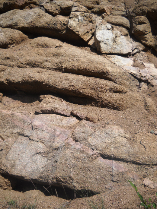
Considering this road cut is relatively new, the surficial weathering that is taking place is also very recent. Since it is relatively recent, the feldspars, quartz, and biotite are still present in both the granitic corestones and grus; however, the biotite are more weathered out than the feldspar and the quartz is the least weathered. Biotite being more weathered is expected because it is a mica that is weaker in structure than feldspars and, especially, the much stronger quartz, both of which contain more silica (Klein, 2007). Another interesting observation in the Doc Long area road cut is the absence of a weathered rind around the granite blocks, as seen in Figure 5. A weathered rind surrounding an unweathered rock is expected in granite because that is the way weathering processes affect granite (Birkeland, 1999).

Hub on the Definition of the Southwest
- What is the Southwest U.S.?
See the beauty of the Southwest and find out why the location of the Southwest is debatable.
The granite may be undergoing chemical decomposition by interactions with rainfall and, perhaps, subsequent small amounts of infiltration; however, since grus is present, the granite appears to be going through significant disintegration caused by shrinking and expanding of the granite. The rock may be shrinking and expanding because of temperature variations during day and night warming and cooling, rock unloading caused by construction during the creation of the road cut, and, especially, biotite expansion. Ritter et. al. (2011) notes similar biotite expansion and, subsequent, disintegration in the Laramie Range of Colorado and in Texas.
In addition, the same rounded corners seen in Sandia granite blocks are also explained in Ritter et. al. (2011) as exfoliation. Exfoliation is taking place because biotite expansion is happening within the vertical fractures and joints that shape the granite blocks peel off the fresh granite over time. The fractures and joints in the blocks are most likely created by tectonic activity in the area, such as the Sandia uplift or the Laramide Orogeny. The expansion and contraction in the fractures and joints is allowing additional weathering to take place near the surface of the granite and creates many of the core stones seen in the Doc Long area. The tectonic activity and expansion and contraction in the fractures and joints may have also helped with the development of the corestone landscape of the lower Sandia Mountains.
Hubs on How Climate Can Affect People
- The Effects of Global Climate Change on Indigenous People
What does climate change mean for indigenous communities across the world? - Climate During and After the Native American Migration to North America
A research paper on how Native Americans migrated through the Bering Strait to the Americas several thousand years ago.
As the overlain Great Unconformity and Sandia Formation above the Sandia granite become more exposed, the granite gives way to limestone. Limestone is a lot more susceptible to weathering, especially chemical weathering caused by rainfall; therefore, it is no surprise that most of the road cut in the Doc Long area is comprised of Sandia granite. However, causes of the varying stages of weathering occurring in the Sandia granite along the road cut cannot be so easily concluded. There are a variety of reasons, including that the more northern portion of the road cut may have been overlain by a thinner limestone deposit that became more weathered over time and, in turn, weathered the Sandia granite more too; or the more southern portion of the road cut may have been lifted more due to tectonic activity in the area. Further analysis would have to be done to come to a more conclusive answer. Nonetheless, since the road cut is relatively young and the Sandia Formation is about 300 Ma and the Sandia Granite is about 1440 Ma, it can be safe to say that the weathering below the Great Unconformity is due to the near-surface processes that occurred prior to the Pennsylvanian transgression.
Works Cited
Birkeland, P., 1999, Soils and Geomorphology, 3rd ed. New York, Oxford University Press. p. 76.
Klein, C. and Dutrow, B., 2007, Mineral Science, 23rd ed, New Jersey, John Wiley and Sons, Inc. p. 470 and 528.
Ritter, D.F, Kochel, C.R., and Miller, J.R., 2011, Process Geomorphology, 5th Ed, Illiniois, Waveland Press, Inc. p. 90-93.
© 2014 morningstar18
Related

Finding the Correlation Coefficient Using Pearson Correlation and Spearman Rank Correlation

How to Find the Average From a Frequency Table

What Is Sand - Formation, Beaches, Composition and Uses

Uranium Mining in Arizona: Mining and the Navajo Tribal People

3 Classifications for Rice Length: Long, Medium and Short Grain


