- HubPages»
- Travel and Places»
- Visiting North America»
- United States
Arches National Park in Utah – A Photographic Journey

Arches National Park

- How Does Wood Petrify?
Petrify literally means turn to stone, so petrified wood means wood turning into stone. Petrified wood has been found in all 50 states and around the world. Many of the areas with the highest concentrations... - The First Must-Do Adventure in Glacier National Park
Glacier National Park in northern Montana is one of the gems of the national park system. But if you want to see the glaciers, you need to go soon. There used to be around 150 glaciers in the park but it is... - Going-to-the-Sun Road: A Drive You Will Never Forget
An excellent adventure at Glacier National Park is a journey by car across the Going-to-the-Sun Road. First, a little bit of background about the road. It was first considered in 1910 but construction was not...
Arches National Park
The original 4,520 acres was set aside as a national monument on April 12, 1929. It was deemed a National Park in 1971 and protects approximately 76,359 acres. Its elevation is between 3,960 & 5,653 feet and it is very exposed. The sun is intense all year round and temperatures can be up to 110 degrees in the summer and down in the single digits in winter. It is strongly advised you carry water at all times when you hike to ward off dehydration and altitude sickness, especially for those who are not used to the elevations.
How Arches Are Formed
The arches in Arches National Park are made from eroded sandstone. It was a long process of weathering that began when the salt domes in the valleys collapsed 30 million years ago. The Cretaceous rocks were removed by weathering exposing the Entrada sandstone.
The Journey
I only had one full day to explore and photograph Arches National Park. Only enough time to hit the highlights. I visited the last day of October, a great time for nice temperatures and fall color. It is definitely on my list of places to revisit.
Delicate Arch
The first stop was to see Delicate Arch at sunrise. I arrived at the park in total darkness with only a map I picked up at the entrance. No one was at the station yet so I could not ask any questions. Sunrise was coming faster than I anticipated so in my rush to get there I missed the turnoff for the trailhead for the 3.0 mile round trip strenuous hike that takes you west of the arch so you can watch the sunrise through it. I ended up at the Viewpoint trailhead. This is a 1.0 mile round trip moderately strenuous climb to a great view of the arch, but on the east side of it. So much for seeing the sunrise through the arch, but I did get some nice morning light on the arch. The altitude was affecting me so I decided against finding the other trail. I’m saving that for the next trip.
Delicate Arch is the best known arch in the world and the most photographed. It is considered a small arch-only 33 feet wide and 45 feet high. But its unusual shape (some think it looks like old-lady’s bloomers or chaps for a bow-legged cowboy) and its location draw photographers from all over the world.

Salt Valley and Fiery Furnace
By this time it was light and I could see where I was going. I decided to head north on the road and see what I had time for in that direction and then head back south and out of the park.
I only had time to stop at these two viewpoints and take a few pictures. You can take a ranger guided tour of the Fiery Furnace area between April and October for a fee, otherwise entry is by permit only. Its name is a good indication of why you not allowed to roam around without the park’s knowledge!


Sand Dune Arch
This was a short 0.3 mile round trip hike through deep sand to a secluded area. It is located in the northern section of Fiery Furnace. You have to navigate a narrow path cut out of the rock to get back to the arch. I was in there by myself and the silence was golden!

Devils Garden
Next was the Devils Garden area.
Broken Arch
This was an easy 1.3 mile round trip hike across a large meadow filled with desert vegetation. The temperature was mild that day but I was still very hot before I got back. I would not want to attempt any of these hikes in the mid-summer’s heat.

Skyline Arch
This is an arch you can actually see from the road. A short easy hike will get you closer. Its size is 69’ long by 45’ high. The opening doubled in size on a November night in 1940 when a large chunk of rock fell out of the arch.

Tunnel Arch
This arch is a short easy hike off the main Devils Garden trail.

Pine Tree Arch
This is another short side trip off the main trail. This one is a little bit of a climb but then it’s easy coming back down. This arch has some beautiful views including some pines, hence the name.

Landscape Arch
On the main Devils Garden trail, this fairly easy hike is a 1.6 mile round trip. It is the second largest known arch with a span of 306’ and it is 106’ high. It is 11’ wide at its widest point and 6’ thick at the thinnest point. This is a must-see because this mature arch is not expected to last much longer. A large rockfall in 1991 made it more slender. No one is allowed on the short trail to this arch anymore because of the danger of rockfalls.

Partition Arch
This arch is visible from Landscape Arch so I did not get very close. I then turned around and retraced my steps back to the car.

Windows Section
This is an easy 1.0 mile round trip hike to three large arches.
North Window
This is one of the most accessible arches so it is very hard to get a photo without people. It has a span of 93’ and a height of 51’.

South Window
This arch is 105’ long and 66’ high. The trail did not go right up to this one so there were no people to wait on to snap a photo.

Turret Arch
This arch has two openings. The largest spans 39’ and is 64’ high.


Double Arch
A short trail leads to this double arch. The largest one measures 163’ long by 105’ high. The smaller one is 60’ long by 61’ high.

Back on the road again and I came to one of Arches’ most famous landmarks.
Balanced Rock
This is a 128’ tall hoodoo. Hoodoos are caused by erosion and some day this one is going to fall down, just like the small spire Chip-off-the-old-Block did sometime during the 1975-6 winter.

Petrified Dunes
Traveling south I next came to the Petrified Dunes Viewpoint. This is the largest area of exposed 200-million-year-old Navajo sandstone in the park. Very scenic viewpoint.

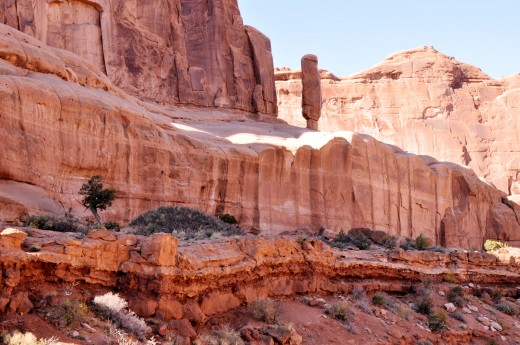
Courthouse Towers
This region has several interesting rock formations.
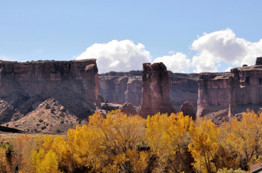
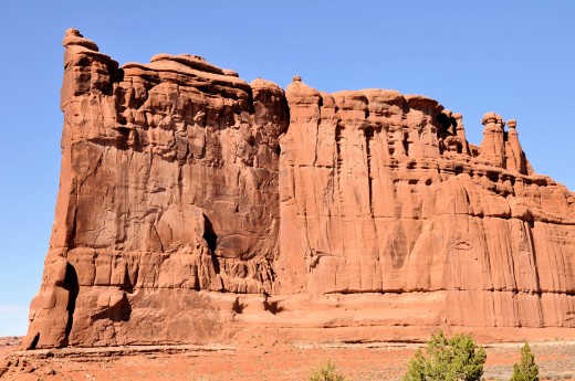
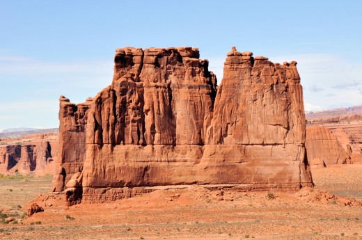
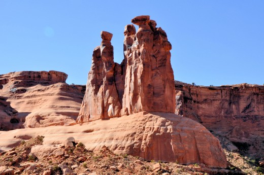
Sheep Rock
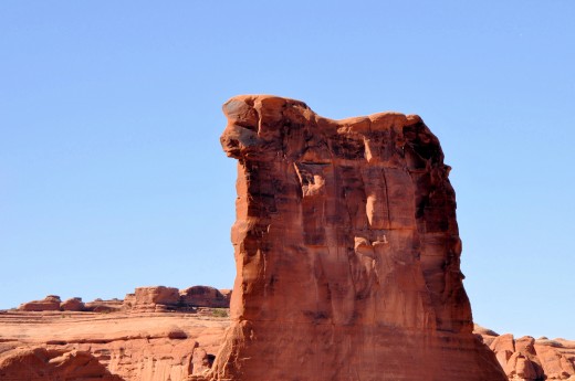
The Three Gossips
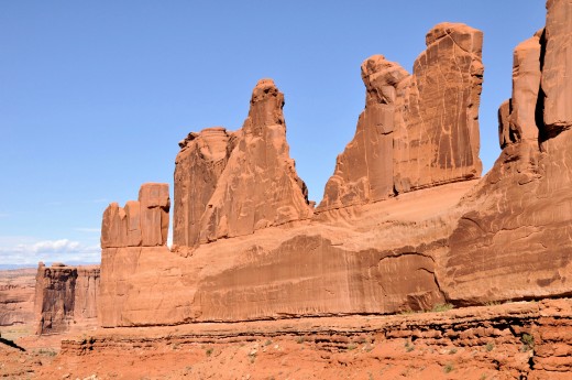
Park Avenue
Last on the main road near the park entrance is the Park Avenue region.
The End of My Day at Arches National Park
There are so many interesting rock formations to see and not enough time to see them all in one day. I will definitely visit again. Now that I know the park, I can plan my time more efficiently and get to the places I want to photograph at the right time of day. I would love to shoot some night photos too.
Arches National Park is definitely an area worth preserving.
All photos are original images of the author. All rights reserved.
Learn More About Arches National Park

Related

Utah's Arches National Park: Amazing Landscape Wonder near Moab

Lanzarote: The Volcanic Landscape of Timanfaya National Park

How to build a brick arch; the beauty, mathematics and history of building arches in architecture

Death Valley National Park: Photos and Impressions of Extremes

Visiting the Beautiful Capitol Reef National Park in Utah


