Visiting the Arctic Watershed near Kenogami Lake, Northern Ontario: historical boundary of Rupert's Land

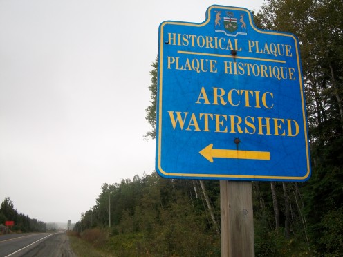
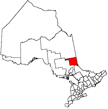
On Highway 11, a historical and topographical boundary is commemorated
In the course of my travels, I have on a number of occasions passed a boundary in Canada, which lies to the north of Kenogami Lake, ON, in the Timiskaming District. The boundary in question is known as the Arctic Watershed.
In topographical terms, the Arctic Watershed is thus named because all streams and rivers to its north run into the Arctic Ocean. Whereas to its south, they all run into the Great Lakes.
Location
This boundary is located 14 kilometres north of Kenogami Lake, intersecting Highway 11, a little north of this road's junction with Highway 66.
Its elevation is 318 metres above sea level.
Roadside signs in both
north- and south-bound directions on Highway 11 mark the approach to this boundary, and a ramp in both directions gives access to a large sign and an historical plaque in English and French, maintained by the Ontario Heritage Foundation, sponsored by the Provincial government.
The Arctic Watershed in history
The
boundary was historically very important, because it marked the southern limit of the huge area known as Rupert's Land, which the Hudson's Bay Company acquired in 1670. In this territory, the Company functioned virtually as a government. The boundary also featured in the 1850 Robinson Superior Treaties between the First Nation Ojibwa and the Crown. Various aspects of treaties with First Nations are subject to ongoing discussion and even controversy, although the role of the Arctic
Watershed in past, historical discussions is an established fact.
A third dimension added to the Continental Divide
In North American geography and history, much is often made of the Continental Divide. Thus, the vast hinterlands of the Atlantic and Pacific coasts are categorized, and the westward movement of Americans in history is often thought of in connection with this roughly north-south line drawn on a map of North America.
Well, there is also a third dimension, which Canadians are maybe a little more aware of, ordinarily: the Arctic Watershed. Much of Canada's vast, northern reaches relates in its fluvial systems neither to the Atlantic Ocean (to which the Great Lakes and their rivers are ultimately connected) nor to the Pacific, but to the Arctic Ocean.
Also worth visiting
Kenogami Lake (distance; approx. 14 kilometres), a small, lakeside community with vacationing and boating opportunities. The Kenogami Bridge Inn is a hub of local activities.
Museum of Northern History , Kirkland Lake (distance: approx. 15 kilometres), housed in the Sir Harry Oakes Chateau. The building, built in 1919, is regarded as a fine example of Prairie/Craftsman architecture.
Timmins (distance: approx. 119 kilometres); the Timmins Gold Mine Tour base located at the former Hollinger gold mine, gives insights into the challenges of working underground and the difficulties experienced by early settlers in Northern Ontario. The Ojibway and Cree Resource Centre, Timmins contains one of the biggest libraries with an Aboriginal emphasis in Canada and the biggest in Ontario. 'La Ronde' Cultural Centre, Timmins (French: Centre Culturel La Ronde ); a focal point, with vibrant activities, for Timmins's large Franco-Ontarian community. Cedar Meadows Resort , situated near the Mattagami River , offers daily wilderness tours; its catering and conference departments have a strong Francophone flavour, with facilities named for Louis Riel, Cartier, Cabot, Champlain, etc. At the Schumacher suburb, adjacent to picturesque Pearl Lake, is a preserved mine shaft, which belonged to the McIntyre Mine; activities of a longstanding, local Croatian community are centred on a Croatian Hall.
Notre-Dame-du-Nord , Quebec (distance: approx. 107 kilometres), municipality scenically located on Lake Temiscaming (French: Lac Témiscamingue ), with its annal Rodéo du Camion (Truck Rodeo) and a fossil theme centre.
Little Claybelt Homesteaders' Museum, New Liskeard , Ontario (distance: approx. 84 kilometres), a heritage and homesteaders' museum, with a Family History Centre and specialisms in glassware, cookbooks, and other aspects of past local life.
...
How to get there: Airlines flying to Timmins Victor M Power Airport include Air Canada, from Toronto Pearson Airport, with wide North American and other connections. Car rental is available at Timmins Airport. (Distance to Timmins Victor M. Power Airport: approx. 131 kilometres.) Air Canada flies from Montreal (Aéroport-Montréal-Trudeau ) to Rouyn-Noranda (Aéroport de Rouyn-Noranda ), where car rental is available. (Distance to Rouyn-Noranda: approx. 101 kilometres). Please check with the airline or your travel agent for up to date information.
MJFenn is an independent travel writer based in Ontario, Canada.
Other of my hubpages may also be of interest
- Visiting Schumacher, in Timmins, Northern Ontario: remembering Croatian heritage
Croatian-Canadians form a large community in Ontario, with numerous Croatian cultural associations being particularly centred in the Greater Toronto Area, particularly Mississauga. The Croatian language has... - Visiting Notre-Dame-du-Nord: western Quebec's scenic municipality where three cultures meet
The west of Quebec province certainly deserves to be better known, and Notre-Dame-du-Nord, in Abitibi-Tmiscamingue region has plenty of rich variety. Temiskaming First Nation The home of Timiskaming... - Visiting Muskoka, Ontario: Gravenhurst's marine and aviation heritage
Gravenhurst, Ontario, situated on Lake Muskoka, in the region also named for the Lake, is well known for its association with the steamer RMS Segwun. Its sister vessel the Wenonah II is also berthed at...


